
A powerful storm is set to impact the Northeast by Tuesday night, potentially intensifying into a bomb cyclone as it moves from the northeastern U.S. to southeastern Canada. AccuWeather meteorologists forecast strong winds, heavy rain, and flooding risks along the Atlantic coast.
The storm will gather strength in the Southeast on Tuesday, bringing thunderstorms to parts of Louisiana, Mississippi, Alabama, and Georgia. These storms could include flooding downpours, damaging wind gusts, and isolated tornadoes.
As the storm moves north along a cold front, mild air will limit wintry precipitation across much of the Northeast on Tuesday night. Heavy rain and above-freezing temperatures will accelerate snowmelt, potentially leading to flooding in areas with significant snowpack, particularly downwind of Lake Erie and Lake Ontario.
Rain is expected to intensify along the I-95 corridor from Florida to Maine by Wednesday. AccuWeather meteorologists warn of significant travel disruptions during both the morning and evening commutes in cities like Washington, D.C., Baltimore, Philadelphia, New York, and Boston. Urban flooding, gusty winds, and reduced visibility due to heavy rain and fog could further complicate travel.
The storm is likely to undergo rapid intensification, qualifying as a bomb cyclone if its central pressure drops 24 millibars in 24 hours. Strong southerly winds could push water levels higher as it tracks northward, causing localized coastal flooding and minor beach erosion, particularly during high tides.
Read also:-
- Anastasiia Smelova: The Beauty Queen on a Mission to Uplift, and Unite Women Worldwide
- HELL’ YA, a song of ELUSIVE THUGS serves as a perfect example of Music with Meaning
- Egyptian-American filmmaker Peter Takla is set to Release his new film, “40 Days,” in theatres on May 30
- Autumn Brockman’s “ARock” Empowers the Beauty Industry
- Miss Universe Guyana organization appoints new Assistant Director Ivonn Novikova
On the storm’s colder backside, temperatures will plummet, potentially causing rain to transition into light snow in parts of the interior Northeast and mountainous regions. Rapidly falling temperatures may also lead to icy road conditions, raising concerns for a freeze-up in parts of the mid-Atlantic and Northeast.
The storm’s aftermath will bring gusty winds across a wide area, impacting both air and road travel. Airports may experience significant delays as winds intensify from Wednesday afternoon into Thursday.
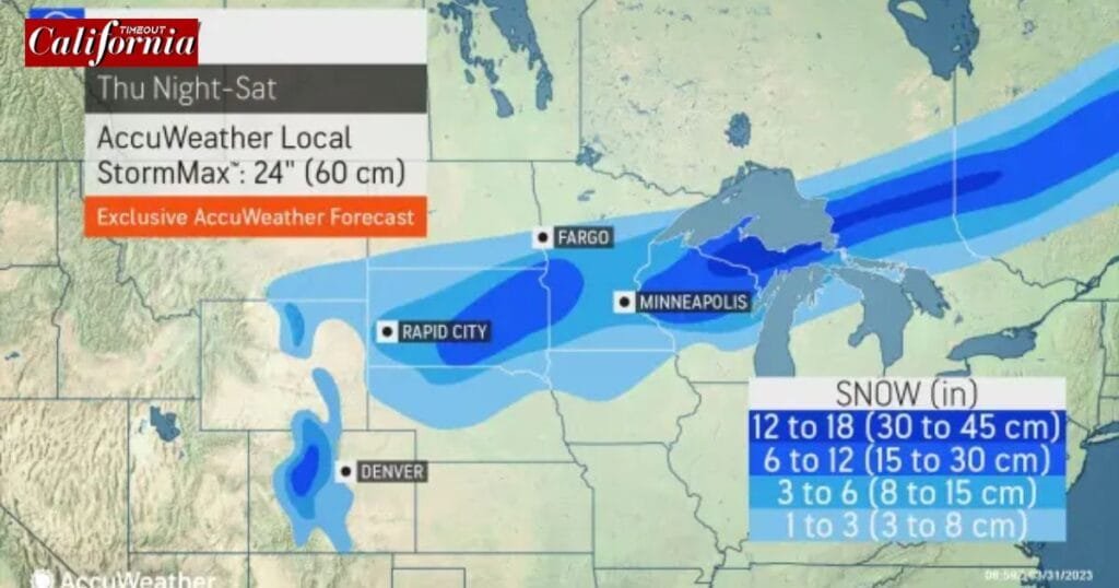
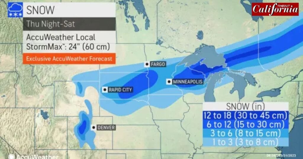
As the storm departs, the Great Lakes region will experience heavy lake-effect snow, disrupting travel from the Upper Midwest to the northern Appalachians between Wednesday and Friday. Though the Arctic air behind the storm won’t be as intense or long-lasting as earlier cold spells, it will create hazardous conditions in affected areas.
Conditions are expected to improve by the weekend, with temperatures potentially climbing above historical averages early next week. While the storm poses significant short-term challenges, its rainfall may provide much-needed relief to drought-affected areas, replenishing streams, lakes, and reservoirs.